Monthly Archive:: June 2014

Google Map Shows Plane debris in Karachi Airport

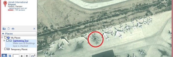
After the recent attack in Karachi Airport, there were images floating in the internet showing Google Maps screenshot of plane blown up like in a plane parking bay. I happen to read the Times of India article, which doubts about the date on which image would have been captured by satellites for Google. After checking

Find When Google Map’s Satellite Image Taken

If you look at the streets or places in Google Maps, you would wonder when these images would have captured by the satellites.  Unfortunately, Google Maps doesn’t show the details of date of the satellite images shown in the maps. But there is a way out to find the date of capture of satellite images